Baja California Sur is the smallest Mexican state by population and the 31st admitted state of the 31 states which, with the Federal District, make up the 32 Federal Entities of Mexico. Before becoming a state on October 8, 1974, the area was known as the South Territory of Baja California. It has an area of 73,475 km2
As of 2010, the population was 637,026. The state is home to the tourist resorts of Cabo San Lucas and San José del Cabo. Its largest city and capital is La Paz, a tourist resort and historic landmark. It includes Loreto, the historic first capital of all three Californias (Baja California Sur, Baja California, and California), the town of Santa Rosalía which is the site of a historic church designed by Gustave
he first inhabitants are thought to have arrived to the peninsula at least 11,000 years ago, to judge by the archaeological discovery of several Clovis pointsin the northern part of the state.The possibility of an even earlier occupation has been raised byradiocarbondates from a site on Isla Espíritu Santo, but this interpretation still remains controversial.
Before phases of the state's prehistory are manifested in several archaeological complexes:
The Las Palmas Complex in the Cape Region and on nearby islands in the Gulf of California is primarily a mortuary pattern. Hallmarks include caves or rock shelters containing secondary burials of human bones painted with red ochre.
The Comondú Complex represents late prehistoric occupation throughout the central portion of the peninsula, perhaps dating between about A.D. 500 and 1700. It is recognized, in particular, by small, triangular projectile points that attest to the introduction of the bow and arrow into the region.
The Great Mural Rock Art is the best-known archaeological phenomenon in northern Baja California Sur. In the Sierra de Guadalupeand Sierra de San Francisco, many rockshelters contain larger-than-life paintings of humans, deer and other animals.
Four distinct ethnolinguistic groups were encountered in Baja California Sur by the early explorers and missionaries: the Pericú in the south, between Cabo San Lucas and La Paz, and on several of the islands in the Gulf; the Guaycura from La Paz to south of Loreto; the Monqui, in the area around Loreto; and the Cochimí, in extensive areas throughout the middle of the peninsula.
Geography and ecology.
Baja california Sur is characterized by deserts, mountains and coastal flatlands. The climate is desert-like in most parts of the state. Plants such as cardon, mezquite and wild-lettuce; animals including mountain lions; and other plants and wildlife characteristic of this ecosystem are found in the Central and Vizcaino Deserts of Baja California Sur.
Parallel to the coast lies the Sierra de la Giganta, with pine and oak forests. To the west, the coastline flatlands form beautiful plains like the Llanos Santa Clara, Magdalena and Hiray, just to name a few.
The Biosphere Natural Reserve of El Vizcaíno, with its 2,500,000 hectares (6,177,635 acres), is the largest natural reserve in Latin America. It is located in the Mulegé municipality and extends from the west end of the Vizcaíno Peninsula and the San Ignacio and Ojo de Liebre lagoons, passing over theSan Francisco Sierra, to the shores of the Gulf of California and the islands in the Gulf of California.
Los cabos
The state is known for its natural features. The Vizcaíno Desert and small coastal lakes San Ignacio and Ojo de Liebre in the north are protected by the federal government. The state includes the Pacific islands of Natividad, Magdalena, and Santa Margarita, as well as the islands of San Marcos, Coronados, Carmen, Montserrat, Santa Catalina, Santa Cruz, San Diego, San José, San Francisco, Partida, Espíritu Santo, and Cerralvo, which are located in the Gulf of California. Rocas Alijos are a group of tiny, steep and barren volcanic islets found offshore.
Numerous flora and fauna are found in Baja California Sur. Notable among the tree species is the Elephant tree, Bursera microphylla, which species exhibits a contorted multi-furcate architecture.
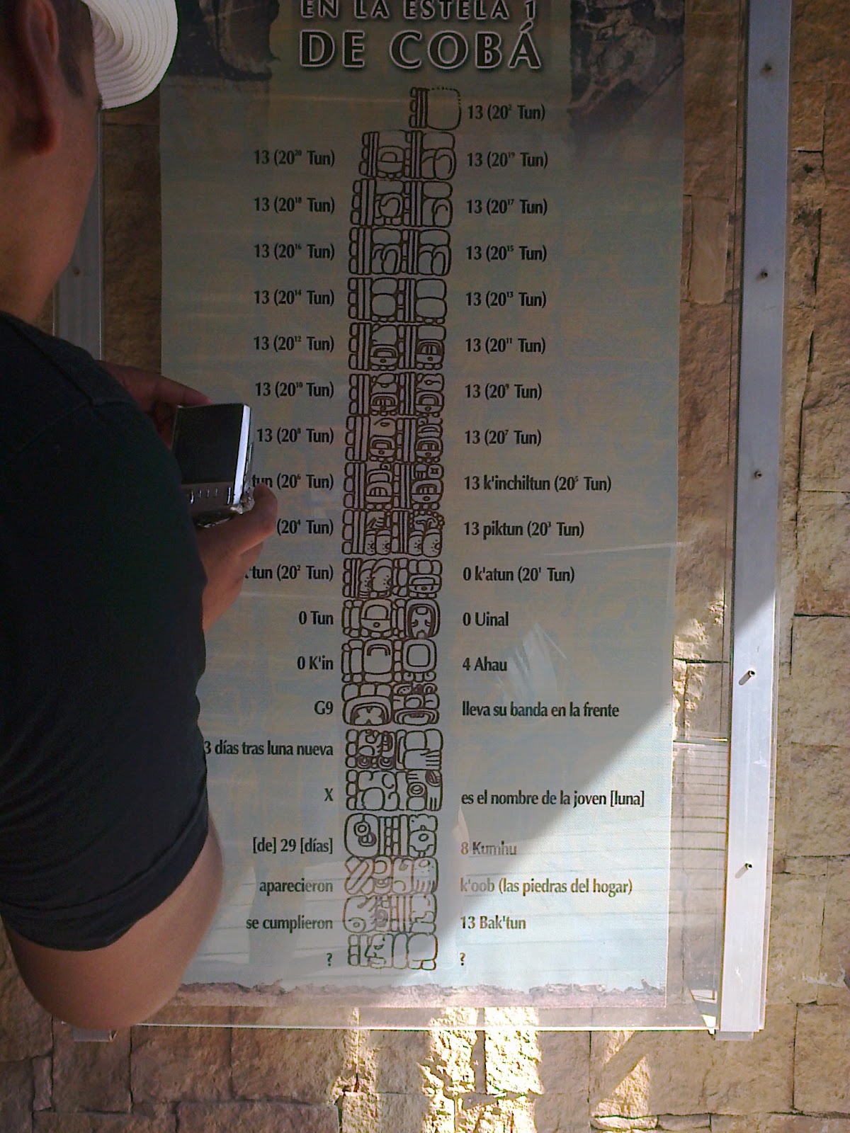
The Long Count is a computer system that was in place
in time from the Late Preclassic Mesoamerica until the end of the Classic.
Although generally attributed to the invention of the Maya Long Count, the
oldest inscriptions in this system have been found in objects associated with
Epi-Olmec culture. There is no single method to correlate the Long Count dates
in the Gregorian calendar. This is because Europeans knew the long count in the
twentieth century, almost ten centuries after it fell into disuse. Among the
proposed correlations, the most widely used is called GMT +2
(Goodman-Martinez-Thompson), which marks the initial date of computation on 11
August 3114. C. 10 11 The Maya script was subsequently deciphered, where much
of his material survived the conquest hieroglyph española.
Unlike the 52-year calendar round still used today
among the Maya, the Long Count was linear, almost cyclical, and calculate the
time in units of 20: 20 days make a uinal, 18 uinals (360 days) made a tun, 20
make a k'atun tunes, and 20 katun (144,000 days) made about b'ak'tun. Thus, the
Mayan date of 8.3.2.10.15 represents 8 baktun, 3 katun , 2 tunes, 10 uinals and 15 days.
Apocalypse
There is a strong tradition of "world ages"
in Mayan literature, but the record has been distorted, leaving several
possibilities opened. According to the Popol Vuh, a book compiling details
of creation accounts known to the Quiche Mayan ethnic group of the highlands of
the colonial era, now living in the fourth world. The Popol Vuh states that the
first gods created three failed worlds, the fourth world succeeded and
prospered, and became the home of modern man. In the long count, every previous
world ended after the thirteenth baktun (5125 years).
The "zero date" of the Long Count is
calculted in 15 on August 11, 3114. C.
In 1957, American astronomer Maud Worcester Makemson
(1891-1977) wrote that "the full phase of a great period of 13 baktuns
could have been of paramount importance to the Mayans' .
In 1966, the religious writer Michael D. Coe said in
his book The Maya that "on the final day of the thirteenth baktun,
Armageddon might surprise the degenerate people of this world and all creation
'.
Objections
In the early nineties, some religious writers (new
age) repeated Coe's apocalyptic vision. While in contrast, later investigated
the baktun end date could be related more to a celebración and not mark the
end of the calendar.
In the prophecies of the Maya, the Aztecs or the
ancient Mesoamericans there is nothing to suggest that they prophesied a sudden
or large of any kind in 2012. The notion of a "Great Cycle" coming to
an end is a thoroughly modern invention.
Mark van Stone (researcher Mayanist)
In 1990, researchers mayanistas Linda Schele and David
Freidel argued that the Maya "did not conceive this to be an end of
creation, as many have suggested."
Susan Milbrath, curator of the Museum of Natural
History in Florida stated that "the archaeological community we have no
record that the Mayans believed that the world would end in 2012."
"For the ancient Maya, it was a grand celebration
that marks the end of a cycle," said Sandra Noble, executive director of
the Foundation for the Advancement of Mesoamerican Studies in Crystal River
(Florida) -. Submit to December 21, 2012 as a doomsday event or moment of
cosmic shifting is a total fabrication and a great opportunity for many people
to get money '.
"It will be another cycle, said E. Wyllys Andrews
V, director of Tulane University. We know the Maya thought there was something
before your calendar, and that implies they were comfortable with the idea that
there was a calendar after '.
"I think popular books [...] about what the
Mayans say will happen are made on very little evidence," said Anthony
Aveni, a professor of Native American studies, anthropology and astronomy at
the University of Colgate.
Due to the large number of inquiries received by NASA
on the subject, published an article that institution as a FAQ ('Frequently
Asked Questions' in English) on the relationship between the 2012 and the
supposed end of the world.
Reference maya the thirteenth baktun.
The contemporary Maya 2012, do not attach any
importance to the thirteenth baktun. Although some Maya groups in the highlands
of Guatemala still use the calendar round, the "long count" was used
exclusively by the classic Maya, and was recently discovered by arqueólogos.
The largest Guatemalan Mayan Apolinario Chile Pixtun
and Mexican archaeologist Guillermo Bernal noted that "apocalypse" is
a Western concept that has little or nothing to do with Mayan beliefs. Bernal
believes that such ideas have been imposed on the Maya by Westerners because
their own myths are "exhausted"
Guatemalan Mayan archaeologist Jose Huchm stated that
"if to some Mayan-speaking communities and asked them about what will
happen in 2012, probably would have no idea about it. What will the world end?
Do not believe it. Currently we have really important issues, like rain '.
The importance that the ancient Maya gave him the
baktun 13 is uncertain. Most classic Maya inscriptions are strictly historical
and do not make any prophetic statement. Two articles in the body text of Mayan
history, however, may make mention of the end of the thirteenth baktun:
Tortuguero Monument Six and the Chilam Balam.
Tortuguero
The inscriptions of Tortuguero, located at the
southern end of Tabasco (Mexico), were written in the seventh century d. C. and
consist of a series of inscriptions in honor of the ruler Bahlam Ajaw. One
inscription, known as Tortuguero Monument Six, is the only inscription
referring to the thirteenth baktun. It was partially damaged. According to a
translation of Sven Gronemeyer and Barbara MacLeod:
tzuhtzjo: m uy-u: xlaju: n pik (to be completed the
thirteenth baktun)
chan ajaw u: x
uni: w uhto: m il? (And a vision happen [?])
ye'ni / e: n bolon Yokte (is the sample-Yokte B'olon)
joyaj chak ta (in a great investment)
Little is known about the god Bolon Yokte. According
to an article by researchers Markus Eberl and Christian Prager (in British
Anthropological Reports), his name is composed of the elements
"nine", 'OK-te' (the meaning of which is unknown), and
"god". Some confusion in the classical period inscriptions suggests
that by that time the name was unfamiliar to ancient scribes. This god also
appears in inscriptions from Palenque, Usumacinta, and La Mar as a god of war
and the underworld. On a pillar is represented with a rope around his neck, and
in another with an incense bag signifying a sacrifice to an end a period of
time.
The 'Chilam Balam'
The Chilam Balam are a group of Mayan prophetic
histories written after the Spanish conquest, transcribed in a modified form of
the Spanish alphabet. Attributed to the chilam balam ('prophets jaguars'). The
Chilam Balam of Tizimin has been translated four times in the twentieth
century, with many disputes over the meaning of its passages. One passage in
particular is relevant to the interpretation of the thirteenth baktun:
Lic u such Oxlahun bak chem, ti u CENIC u (tzan to cen
/ ba nacom) i (CIAC / cha ') a ba yum (il / t) exe.
Maud Worcester Makemson Archaeologist (1891-1977)
believed that this line referred to a "tremendously important event of the
arrival of 13.0.0.0.0 4 Ahau 3 Kankin in a not too distant future." His
translation of the line says:
Soon, the thirteenth baktun come sailing, figuratively
speaking, bringing the ornaments that I have mentioned of your ancestors.
His version of the text continues, "Then the god
will come to visit their children. Perhaps, "after death" is the
theme of his speech. " 13.0.0.0.0 Makemson dated in 1752 and, therefore,
the "not too distant future" in her annotations meant a few years
after the scribe in Tizimín recorded his Chilam Balam. The most recent
translation of Munro S. Edmonson does not support this reading, he believes
that the Long Count is almost entirely absent from the book, because the
360-day tun was replaced about 1750 by a 365-day Christian year. He translates
the line as follows:
... As the arrival of thirteen sailboats. When the
captains dress, her parents will tomados.
Other Chilam Balam books contain references to the
thirteenth baktun, but it is unclear whether dealing with past or future, eg
oxhun bakam or katunil (bakam thirteen katun) in the Chilam Balam of Bolon
Chumayel.30 Yokte 'appeared K'uh In the Chilam Balam of Chumayel means an
apparent battle or victory against invaders españoles.
Dates beyond the thirteenth baktun
Temple of Inscriptions
Many inscriptions occasionally referenced future events or commemorations that would occur on dates that lie beyond the full phase of the thirteenth baktun. Many of these are in the form of "distant dates" which gives a Long Count date, together with a Distance Number that is added to the Long Count date of arrival at that future date. In a west panel at the Temple of Inscriptions in Palenque, a section of text projections in the future towards the eightieth anniversary of the Calendar Round of Palenque ruler K'inich Janaab 'Pakal accessing the throne (Pakal's rise occurs in 9.9.2.4.8; equivalent to July 27, 615 CE in proleptic Gregorian calendar). To do this, starting with Pakal's birthdate of 9.8.9.13.0 (March 24, 603 CE, Gregorian date) and adding to this the number Distant 10.11.10.5.8.32
This calculation comes at the eightieth Calendar Round anniversary since his ascension, which is located at 4000 years after the time of Pakal: October 21, 4772 to. C.33 32 34
Another example is one in Coba Stela, delivering a 13.13.13.13.13.13.13.13.13.13.13.13.13.13.13.13.13.13.13.13.0.0.0.0 date., Or twenty units above the baktun, placing it either 4.134105 × 1028 (41 octillion) years in the future, or an equal distance in the pasado.34 However, this date is three quintillion times an era in the universe, demonstrating that not all .
The Free and Sovereign State of Sinaloa is one of the 31 states with the Federal District comprise the 32 states Hotels.com guest. It is located northwest of the country, on the coast of the Gulf of California, bordered on the north by Sonora, Chihuahua and Durango east (separated from them by the Sierra Madre Occidental) and Nayarit to the south. Its capital is Culiacán, an industrial and agricultural importance, with approximately 858.638 inhabitants. Next in importance and size Mazatlán major tourist destination, and fishing port with approximately 438.434 inhabitants, and Los Mochis, an agricultural center, fishing, tourism and industry with approximately 416.299 inhabitants.
Sinaloa is the most important agricultural state of Mexico, in addition, has the second largest fishing fleet in the country. Culturally, it is known nationally and even internationally for its traditional music, or Tambora Band. The Ulama, regional version of the pre-Hispanic ball game, is still practiced in the state.
Sinaloa is located on a naturally fertile region, has 11 rivers and 12 reservoirs, the newest of which Picachos Dam, located in the Rio Presidio at the boundaries of the municipalities of Mazatlán and Concordia. It has 656 kilometers of coastline belonging mostly to the Gulf of California and the Pacific Ocean. Besides having 12 bays and 15 estuaries.
Sinaloa is divided into 18 municipalities (listed north to south): Choix, El Fuerte, Ahome, Guasave, Sinaloa, Mocorito, Angostura, Salvador Alvarado, Badiraguato, Culiacán, Navolato, Cosalá, Elota, San Ignacio, Mazatlan, Concordia, Rosario and Escuinapa.
Climate
The state has 48% subhumid warm climate located in a
northeast-southeast strip stretching from Choix to the border with Nayarit, 40%
is dry and semidry present in a belt stretching from El Fuerte to Mazatlan, 10%
is very dry and is located in the Los Mochis, the remaining 2% is temperate
subhumid located in the highlands of the Sierra Madre Occidental.
The average annual temperature in the state is around
25 ° C, the average minimum temperatures are about 10.5 ° C in January and the
highest average may be higher than 36 ° C during the months of May to July.
Most rainfall occurs in the summer during the months
of July to September, the state's average rainfall is 790 mm per year.
Sinaloa is national agricultural producer, the main
growing areas are in dry and semi-dry climates, so it requires irrigation being
the main crops: corn, beans, potatoes, safflower, soybean, cotton, sorghum,
chickpeas and safflower among others. In the region with warm humid climate is
grown tomatoes, watermelon, melon, vegetables and fruits like mango, in its
different varieties Kent, Tommy and Keiit mainly.
40% dry and semidry
Warm humid 48%
Very dry 10%
Temperate subhumid 2%
Surface
Sinaloa has an area of 57,365 square kilometers
(km2), therefore ranks 18 nationally.
Percentage territorial
The state of Sinaloa represents 2.9% of the country's
area.
Coastal
Sinaloa has 622 km of coastline, representing 5.6% of
the national total.
Population
According to data II threw the Population and Housing
Census conducted by the National Institute of Statistics and Geography (INEGI)
with census date of 12 June 2010, the state of Sinaloa until this year had a
total of 2,767,761 inhabitants of that number, 1,376,201 were men and 1,391,560
were women.2 The annual growth rate for the entity during the period 2005-2010
was 1.2%.
Nuevo Leónis astatelocated in northeasternMexico. It borders the states ofTamaulipasto the north and east and San Luis Potosíto the south, andCoahuilato the west. To the north, Nuevo León accounts for a 15 kilometer (9 mi) stretch of theU.S.-Mexico borderadjacent to the U.S. stateofTexas.
The capital of Nuevo León isMonterrey, other important cities includeGuadalupe, Santa Catarina,San Nicolás de los Garza, andSan Pedro Garza García, all of which are part of theMonterrey Metropolitan area.
Geography
The capital of Nuevo León isMonterrey, other important cities includeGuadalupe, Santa Catarina,San Nicolás de los Garza, andSan Pedro Garza García, all of which are part of theMonterrey Metropolitan area.
Nuevo León has an extreme climate, and there is very little rainfall throughout the year. The territory covers 64,924 square kilometers (25,067.3 sq mi), and can be divided into three regions: a hot, dry region in the north, a temperate region in the mountains, and a semi-arid region in the south. TheSierra Madre Orientalmountain range affects in an important way the lay of the land forming the Galeana and Doctor Arroyo plateaus, the Iguana, Picachos, Papagayos, and Santa Clara mountain ranges, and the Pilón, Ascensión, and Río Blanco valleys. As for hydrography, theSan Juan Riversupplies the El Cuchillo dam, which provides water forMonterreyand the metropolitan area.
Presa de la boca
There are also the Cerro Prieto, La Boca, Vaquerías, Nogalitos, and Agualeguas dams.Laguna de Labradoresis a major lake in Nuevo León, andPozo del Gavilánis a natural well. Both are located in theGaleanamunicipality.
Pozo del Gavilan
The flora of the region includes brush and pastures in the low regions, and pine and oak trees in the mountains. The fauna includesblack bears,mountain lions,javelinas,prairie dogs,foxes,coyotes, andwhite-tailed deer, along with smaller species.
Coahuila, formallyCoahuila de Zaragoza, officiallyEstado Libre y Soberano de Coahuila de Zaragoza(Free and Sovereign State of Coahuila de Zaragoza) is one of the 31 states which, with the Federal District, comprise the 32 federal Entities of Mexico. The state is located in Northeastern.
Coahuila borders the Mexican states of Nuevo Leonto the east, Zacatecasand San Luis Potosito the south, and Durangoand Chihuahuato the west. To the north, Coahuila accounts for a 512 kilometers (318 mi) stretch of the U.S. - Mexico border, adjacent to the United States stateof Texasalong the course of the Rio Grande (Rio Bravo). With an area of 151,563 square kilometers (58,518.8 sq mi), it is the nation's third-largest state. It comprises 38 municipalities. In 2010, Coahuila's population is 2,655,187 inhabitants.
The capital of Coahuila is Saltillo, and its largest city is Torreon. Coahuila also includes the cities of Monclova(a former state capital), Piedras Negras, and Ciudad Acuña.
Geography
TheSierra Madre Orientalruns northwest to southeast through the State, and the higher elevations are home to theSierra Madre Oriental pine-oak forests.
East of the range, the land slopes gently toward the Rio Grande, and is drained by several rivers, including theSaladoand its tributary the Sabinas. TheTamaulipan mezquital, adry shrublandecoregion, occupies the eastern portion of the State, and extends across the Rio Grande into southern Texas.
The portion of the State west of the Sierra Madre Oriental lies on theMexican Plateau, and is part of theChihuahuan Desert. TheBolsón de Mapimíis a largeendorheic basinwhich covers much of the western portion of the State and extends into adjacent portions of Chihuahua, Durango, and Zacatecas. TheNazas River, which flows east from Durango, and theAguanaval River, which flows north from Zacatecas, empty into lakes in the Bolsón.Torreón, the most populous city in the State, lies on the Nazas in the irrigatedLaguna Region, the(Comarca Lagunera), which straddles the border of Coahuila and Durango.
Coahuila contains twobiosphere reserves.Maderas del Carmenlies on the northern border of the State, and includes sections of the Chihuahuan desert andsky islandsof pine-oak forest in theSierra del Carmen. The springs, lakes, and wetlands ofCuatro Ciénegaslie west of Monclova on the west slope of the Sierra Madre.
Cuatrocienegas
Las playitas- Cuatrocienegas
(oasis in the desert)
Desert of Cuatrocienegas
Boquillas del Carmen- National Park
Coahuila is largely arid or semi-arid, but the rivers of the State support extensive irrigated agriculture, particularlycotton. TheParrasdistrict in the southern part of the State produces wines and brandies. Thepine-oak forestsof the Sierra Madre produce timber.
Yucatan, Tierra del Mayab, is a legendary land That offers impressive archaeological sites, Historical stately cities, caves, cenotes, beaches, Mayan communities, music and gastronomy Live culture, legacy of our ancestors…
Yucatan is a perfect fusion of past and present, It is a constant dance of colors, aromas, sounds, flavors, textures.. It is a never ending mosaic of prodigies to be discovered…
Here we like to smile and make our visitors smile, The hospitality, the human warmth and our singularity, Distinguishes us and we feel proud to offer it to our visitors. To know Yucatan is a unique experience, always different.