Mar 27, 2011

Nuevo Leon


Nuevo León is a state located in northeastern Mexico. It borders the states of Tamaulipas to the north and east and San Luis Potosí to the south, and Coahuila to the west. To the north, Nuevo León accounts for a 15 kilometer (9 mi) stretch of the U.S.-Mexico border adjacent to the U.S. state of Texas.

The capital of Nuevo León is Monterrey, other important cities include Guadalupe, Santa Catarina, San Nicolás de los Garza, and San Pedro Garza García, all of which are part of the Monterrey Metropolitan area.

Geography


The capital of Nuevo León is Monterrey, other important cities include Guadalupe, Santa Catarina, San Nicolás de los Garza, and San Pedro Garza García, all of which are part of the Monterrey Metropolitan area.

Nuevo León has an extreme climate, and there is very little rainfall throughout the year. The territory covers 64,924 square kilometers (25,067.3 sq mi), and can be divided into three regions: a hot, dry region in the north, a temperate region in the mountains, and a semi-arid region in the south. The Sierra Madre Orientalmountain range affects in an important way the lay of the land forming the Galeana and Doctor Arroyo plateaus, the Iguana, Picachos, Papagayos, and Santa Clara mountain ranges, and the Pilón, Ascensión, and Río Blanco valleys. As for hydrography, the San Juan River supplies the El Cuchillo dam, which provides water for Monterrey and the metropolitan area. 
Presa de la boca

There are also the Cerro Prieto, La Boca, Vaquerías, Nogalitos, and Agualeguas dams. Laguna de Labradores is a major lake in Nuevo León, and Pozo del Gavilán is a natural well. Both are located in the Galeana municipality.

Pozo del Gavilan

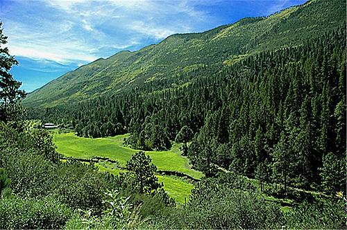
The flora of the region includes brush and pastures in the low regions, and pine and oak trees in the mountains. The fauna includes black bears,mountain lions, javelinas, prairie dogs, foxes, coyotes, and white-tailed deer, along with smaller species.

Huasteca

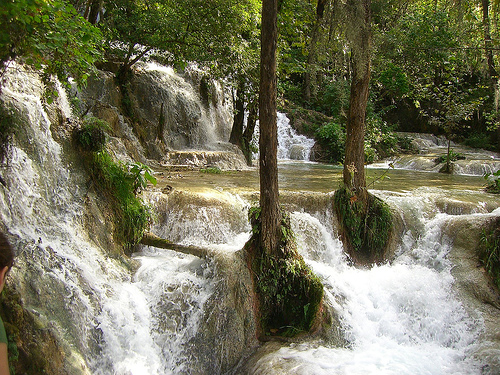
El salto


Grutas de García

Laguna de labradores (galeana)


Video of Nuevo Leon 

Mar 14, 2011

COAHUILA

Coahuila, formally Coahuila de Zaragoza, officially Estado Libre y Soberano de Coahuila de Zaragoza (Free and Sovereign State of Coahuila de Zaragoza) is one of the 31 states which, with the Federal District, comprise the 32 federal Entities of Mexico. The state is located in Northeastern.


Coahuila borders the Mexican states of Nuevo Leon to the east, Zacatecas and San Luis Potosi to the south, and Durango and Chihuahua to the west. To the north, Coahuila accounts for a 512 kilometers (318 mi) stretch of the U.S. - Mexico border, adjacent to the United States state of Texas along the course of the Rio Grande (Rio Bravo). With an area of 151,563 square kilometers (58,518.8 sq mi), it is the nation's third-largest state. It comprises 38 municipalities. In 2010, Coahuila's population is 2,655,187 inhabitants.

The capital of Coahuila is Saltillo, and its largest city is Torreon. Coahuila also includes the cities of Monclova (a former state capital), Piedras Negras, and Ciudad Acuña.


Geography

The Sierra Madre Oriental runs northwest to southeast through the State, and the higher elevations are home to the Sierra Madre Oriental pine-oak forests.
East of the range, the land slopes gently toward the Rio Grande, and is drained by several rivers, including the Salado and its tributary the Sabinas. The Tamaulipan mezquital, a dry shrubland ecoregion, occupies the eastern portion of the State, and extends across the Rio Grande into southern Texas.
The portion of the State west of the Sierra Madre Oriental lies on the Mexican Plateau, and is part of the Chihuahuan Desert. The Bolsón de Mapimí is a large endorheic basin which covers much of the western portion of the State and extends into adjacent portions of Chihuahua, Durango, and Zacatecas. The Nazas River, which flows east from Durango, and the Aguanaval River, which flows north from Zacatecas, empty into lakes in the Bolsón. Torreón, the most populous city in the State, lies on the Nazas in the irrigated Laguna Region, the (Comarca Lagunera), which straddles the border of Coahuila and Durango.
Coahuila contains two biosphere reserves. Maderas del Carmen lies on the northern border of the State, and includes sections of the Chihuahuan desert and sky islands of pine-oak forest in the Sierra del Carmen. The springs, lakes, and wetlands of Cuatro Ciénegas lie west of Monclova on the west slope of the Sierra Madre.

Cuatrocienegas

Las playitas- Cuatrocienegas
(oasis in the desert)

Desert of Cuatrocienegas

Boquillas del Carmen- National Park

Coahuila is largely arid or semi-arid, but the rivers of the State support extensive irrigated agriculture, particularly cotton. The Parras district in the southern part of the State produces wines and brandies. The pine-oak forests of the Sierra Madre produce timber.

Monterreal- Arteaga mountains

Monterreal- Arteaga mountains

Parras Madero

Video of Coahuila

Mar 1, 2011

YUCATAN


Yucatan, Tierra del Mayab, is a legendary land That offers impressive archaeological sites, Historical stately cities, caves, cenotes, beaches, Mayan communities, music and gastronomy Live culture, legacy of our ancestors…
Yucatan is a perfect fusion of past and present, It is a constant dance of colors, aromas, sounds, flavors, textures.. It is a never ending mosaic of prodigies to be discovered…
Here we like to smile and make our visitors smile, The hospitality, the human warmth and our singularity, Distinguishes us and we feel proud to offer it to our visitors.  To know Yucatan is a unique experience, always different.
Yucatan


Feb 28, 2011

Geography of Mexico


Mexico is a country in North America. The United States is north of Mexico. Guatemala and Belize are south of Mexico. Mexico is between the Pacific Ocean and the Gulf of Mexico.

People living in Mexico or who are from there are called Mexicans. Most Mexican people speak Spanish. There are also Mexicans who speak Native  languages, like Nahuatl, Maya, and Zapotec. The capital of Mexico is Mexico City.

Mexico is in the southern part of North America and is roughly shaped like a triangle. Mexico is more than 3000 km (1,850 miles) long from northwest to southeast. Mexico is between two large seas: the Pacific Ocean in the West and the Gulf Mexico and the Caribeann Sea in the East. Mexico has two large peninsulas.

Baja California in the Northwest, and Yucatan in the Southeast. In central and western Mexico are the Sierra Madre mountains. In the Sierra Madre is the Pico de Orizaba, the highest mountain of Mexico. In central Mexico there are also a few volcanoes like the Popocatépetl and the Iztaccihuatl.


The Pico de Orizaba is also a volcano. In the north of Mexico are deserts, in the south are tropical rainforest. Some rivers in Mexico are the Rio Bravo (known in the US as the Rio Grande), the Rio Grijalva, the Rio Balsas, the Rio Panuco, and the Rio Yaqui.


Feb 26, 2011

QUINTANA ROO


Cancún is a coastal city in Mexico's easternmost state,Quintana Roo, on the Yucatán Peninsula. As a rapidly growing city with a quickly changing skyline, the estimated population for Cancún is 705,000 in 2010, a 20% increase from the census in 2005. Cancún is located on the Yucatan Channel that separates Mexico from the island of Cuba in the Greater Antilles. The Cancún region is sometimes known as theMexican Caribbean or the Mayan Riviera.

Cancún is the municipal seat of the Benito Juarez municipality and a world-renownedbalneario and tourist resort. The city center is located on the mainland which connects the Nichupté and lagoons to a narrow 7-shaped island where the modern beachfront hotels are located in the tourist centric hotel zone.


Video of the state of Quintana Roo